





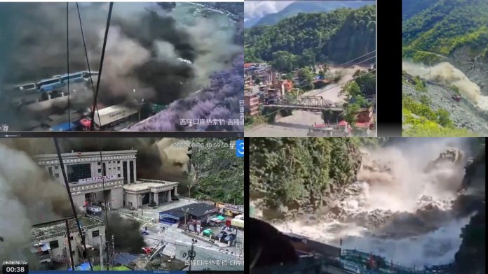
Sudden flash floods are causing alarm worldwide. Recently, floods struck suddenly in Arunachal Pradesh in India, and now flash floods have swept through Nepal, leaving more than 1,000 people missing so far. Differing explanations have emerged over what caused these floods, and the situation in Nepal suggests that similar threats could confront other countries in the future as well. Analysts point to two possible causes behind the Nepal floods: first, the warming of the Himalayas causing water to accumulate in unstable locations, which then suddenly surged following ground tremors; and second, the ongoing formation of the Himalayan mountain range as two tectonic plates continue to collide with each other.
Nepal’s Disaster Management Authority stated that satellite imagery showed massive snow and rock avalanches near the Nepal-China border caused by the earthquake. Prior to this, a professor at Kathmandu University revealed that large snow deposits had accumulated across the Langtang (Lende) river, causing significant water buildup. The professor suggested that when the snow and rock deposits blocking the river suddenly collapsed, the pent-up water from the Lende river surged rapidly into the Bhote Koshi river, triggering the flash floods. It was further noted that an earthquake occurred in Tibet around the same time, and it is believed that the resulting tremors caused the snow deposits to break apart, leading to the floods.
The Lende river, currently linked to the floods in Nepal, is a tributary of the Bhote Koshi river. It originates in Tibet and crosses the border into Nepal, where it merges with the Bhote Koshi river. Further downstream, the Bhote Koshi transforms into the Trishuli river, which then merges with the Kali Gandaki river at Devghat in Nepal, at which point it becomes known as the Narayani river. This river subsequently enters India through Bihar, where it is known as the Gandak river, flowing along the Bihar-Uttar Pradesh border before eventually merging into the Ganga.
Nepal’s Foreign Minister Shishir Khanal has expressed a separate view, suggesting that the earthquake in Tibet may have caused the floods in his country. Minister Khanal stated that preliminary assessments suggest the Tibet earthquake caused landslides that triggered the flooding of the Bhote Koshi river in Nepal. The US Geological Survey reported that a magnitude 4.4 earthquake struck Tibet on Wednesday morning at 8:37 am. Experts are currently investigating what exactly occurred. Meanwhile, a video showing a massive flood surge in the Gyirong Port area of Tibet, adjacent to Nepal’s flood-affected Rasuwa district, has gone viral on social media.
Separately, scientists have also pointed to the melting of glaciers in the Hindu Kush region as a contributing factor. Since 2000, glacial melting in the Hindu Kush mountain ranges of the Himalayas has increased significantly, with the resulting meltwater forming glacial lakes in unstable locations. These lakes effectively act like water bombs perched on the mountains, and when ground movement or other triggers cause them to suddenly burst, they surge downstream and cause flash floods. The UN Development Programme (UNDP) had already identified 3,624 glacial lakes across the Koshi-Gandaki-Karnali basins back in 2020, of which 47 were flagged as extremely dangerous — 25 located in Tibet, 21 in Nepal, and one in India.
Experts note that the continued absence of early-warning technology capable of detecting glacial lake outburst floods and avalanches in advance is making Nepal increasingly vulnerable. Compounding this, Nepal lies at the zone where the Indian and Eurasian tectonic plates meet, moving closer together by roughly 20-21 millimeters each year — a process that has continued since the two plates first collided nearly 50 million years ago, forming the Himalayas, which continue to rise at a rate of around 5 millimeters annually, making it the fastest-growing mountain range on Earth today.
Scientists believe the immense pressure generated by this ongoing uplift is a contributing cause of earthquakes in the region, and that tremors from such earthquakes have repeatedly caused glacial lakes to burst and surge downstream, heightening flood risk — with Wednesday’s flood disaster also believed to have been triggered by a glacial lake outburst caused by the earthquake in Tibet.