





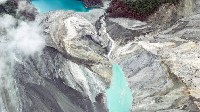
The sudden and devastating floods that struck Nepal have left the country reeling, claiming hundreds of lives, flattening thousands of structures, and leaving many people missing. Even as rescue operations continue for those still unaccounted for, another alarming development has once again sent shockwaves through the country, making it clear that the flood threat to Nepal is far from over. Experts have identified a “barrier lake”—a lake formed by a natural ice or debris blockage—in the Himalayan region, located at the confluence of the Chochen Khola and Purepu Tsangpo rivers.
Amid the fear and anxiety already gripping people following Nepal’s catastrophic floods, reports indicate that further danger may still be looming. According to a CCTV report, Chinese authorities have identified a barrier lake in the upper reaches of a Himalayan border crossing, which could pose a significant obstacle to ongoing rescue efforts. According to Chinese state media, the country’s Ministry of Water Resources has stepped up monitoring and investigation of the lake, which formed at the confluence of the Chochen Khola and Purepu Tsangpo rivers, northeast of the disaster site, in order to support rescue operations and prevent further disasters.
The barrier lake, which held an estimated 2 million cubic metres of water as of Thursday, is already overflowing. According to a report by China Central Television, an additional 3 million cubic metres of water is expected to flow into the lake over the next 72 hours. Chinese authorities have deployed an eight-member engineering team to conduct an aerial survey of the lake and prepare a 3D model of the site. Chen Hangxiao, one of the engineers involved, said that reaching the location itself has proven to be the most difficult challenge, explaining that after the glacier collapse formed the lake, extremely steep rock faces developed along its banks.
To reduce the risk posed by the lake, engineers typically dig a channel at the base of the naturally formed barrier to drain water out, Chen said, though the width and depth of such a channel must be calculated based on the rate of water flow and how quickly the lake is filling up. According to survey data, the lake is around 150 metres long and 40-50 metres deep, and is estimated to already hold between 1.5 and 2 million cubic metres of water.
Chinese authorities said on Thursday that continuous monitoring of the lake, data collection from its base, and tracking of weather conditions in the coming days would be their immediate priorities. Light to moderate rainfall in the Gyirong border port area has already loosened soil and rocks around the hazardous zone upstream, with more rain expected through the coming week. Officials said an additional 3 million cubic metres of water — roughly equivalent to 1,200 Olympic swimming pools — is expected to flow into the naturally dammed lake over the next three days, raising the risk of the barrier breaching, with water inflow expected to peak around September 1. Aerial footage taken by a Chinese rescue team showed brownish water pooling in a basin with no clear outlet, already submerging bushes and trees and placing significant pressure on the blockage formed by rocks and debris.
While India does not share a direct border with the site, it remains connected through the river system. The barrier lake lies roughly 120-140 kilometres north of India, and water from the Chochen Khola and Purepu Tsangpo rivers flows rapidly through Nepal before entering Bihar via the Gandak river. Should pressure build up further or the natural dam breach, triggering a sudden outburst flood, the resulting surge of water, debris, trees, silt and boulders could cause severe damage downstream. Water from the two rivers first enters Nepal’s river system, where it merges with the Bhote Koshi and subsequently the Trishuli river, before flowing into the Gandak, or Narayani, river and eventually into India.
This means that although India has no direct link to the lake itself, the river system through which the water flows could affect Bihar and Uttar Pradesh, with officials cautioning that a sudden rise in water flow upstream could compound hardships for people living in downstream areas. Experts say the situation ahead will depend on whether the lake’s water remains stable or surges downstream rapidly, and officials have said the river’s flow pattern cannot be accurately assessed until another 72 hours have passed.